
Brownsville Neighbors Around a Block
The public record trail around a Brownsville address begins with the city's GIS layers, then moves parcel by parcel to CAD and the County Clerk. The GIS map shows the physical pattern of a block. CAD can provide the current property account, situs and mailing fields, value, exemptions, and legal description. The Clerk's index documents recorded instruments. Permit reports can date site work. A historical directory may place an occupant at a street address for a printed year. Each source has a different time frame and purpose, so it is important not to turn one result into a complete neighbor roster.
| Source | What it shows about a block | Access |
|---|---|---|
| Brownsville GIS County Parcels | Parcel shapes, adjacency, and city, ZIP, district, zoning, and street context. | Public map; boundaries are approximate and not a survey. |
| Address Points and Streets | Address points, street names, intersections, and sequence along a segment. | Public map layers and layer guide. |
| Cameron CAD | Owner or account information, situs, mailing address, value, and exemptions for one selected parcel. | Public portal and FAQ; search each parcel separately. |
| County Clerk deed index | Recorded owners and instruments tied to party names and legal descriptions. | Current and historic county portals. |
| City permit reports | Address-related work and inspection chronology where fields are public. | Reports for 2015 through 2026; older records require a request. |
| Historical directories | Address-section household entries and printed annotations for a particular year. | Library, archives, and collection leads; complete reverse run not located. |
For a current block question, record the source date, active map layers, parcel identifier, and type of result. That small audit trail prevents a map label, tax mailing address, and recorded deed party from being mistaken for the same sort of evidence.
Map a Brownsville Block Parcel by Parcel
The documented adjacent-parcel method uses the One City Interactive Web Map's Address Points, County Parcels, and Streets layers. The research did not verify its popup field list, click-select behavior, radius tool, buffer tool, measure tool, or export control. That limitation matters. Use the map to locate and visually compare nearby polygons, then use CAD and the Clerk for record evidence rather than asserting that the map alone establishes a legal boundary or ownership.
- Locate the target address in the Brownsville GIS map and turn on Address Points, County Parcels, Streets, and Street Intersections.
- Zoom until the target parcel, both side parcels, rear parcel, corner parcel, and any alley, resaca, railroad, or public right-of-way are visible.
- For each apparent adjacent polygon, save the visible address context and PID or GEO ID if the loaded map exposes it. Do not assume a visual neighbor is a private parcel.
- Search each saved address, PID, or GEO ID in the Cameron County Appraisal District and label situs and mailing fields separately.
- Use the legal description and recorded party names in the County Clerk index when the question concerns title history, then preserve document references and dates.
The Brownsville street directory follows the longer chain along a named street. This block method stays focused on the parcels touching or immediately surrounding one address.
Brownsville CAD Accounts by Parcel
CAD's FAQ documents owner name, address, PID number, and GEO ID number as search modes. Its property record can provide a description, ownership, exemptions or special valuations, taxing units, and estimated tax-year amount. The CAD portal did not expose a verified whole-block, street, ZIP, export, or sort mode during research. The repeatable process is one account at a time after GIS has established the possible parcel set.
Pay special attention to situs and mailing address. Situs is the physical location of the parcel. Mailing is where tax notices go and can be another home, a post-office box, a business, or a later correspondence address. A homestead exemption may be evidence related to owner occupancy, but it is not proof of every person present at a property and does not establish a current household list. CAD also does not issue deeds or subdivision plats. Those records belong with the County Clerk.
- PID or GEO ID
- A CAD property identifier that helps carry a map result into the property search.
- Situs
- The parcel's physical address, distinct from a tax-notice mailing destination.
- Legal description
- The title description, such as lot and block, used to follow a parcel into recorded instruments.
- Parcel adjacency
- Nearby polygon placement on a map, which must be checked because the city map is approximate.
Note: Save the active layers and CAD search date before comparing Brownsville neighbor records, because portal data and parcel configurations can change.
Brownsville Community Directory Records
Community records add area identity, not a list of residents. The Texas HOA Management Certificate Search returns management-certificate entries with an association name, city, ZIP, type, and certificate information. The state warns that the database relies on user submissions and that completeness, reliability, and validity cannot be guaranteed. A certificate is not a membership directory or a record of every address within an association.
| Brownsville association example | ZIP shown | What the state search supports |
|---|---|---|
| Madeira Residential Association | 78520 | Management-certificate search result and association name. |
| Creekwood Homeowner's Association | 78521 | Management-certificate search result and association name. |
| Heron Cove Estates | 78521 | Management-certificate search result and association name. |
| Portofino | 78521 | Management-certificate search result and association name. |
| Brownsville Winter Haven Property Owners' Association | 78526 | Management-certificate search result and association name. |
| Fox Hollow Homeowner Association | 78526 | Management-certificate search result and association name. |
The state search screen is the documented source for the association records used here.
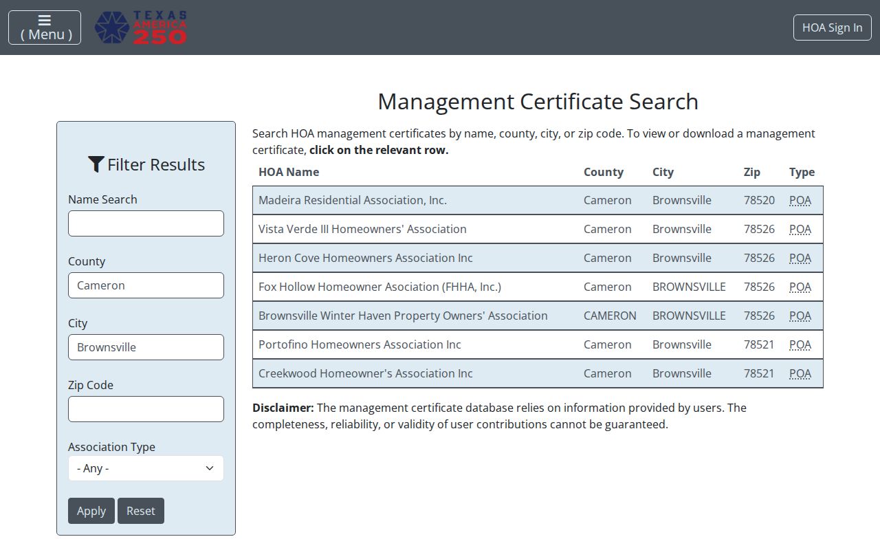
The image supports the association and ZIP layer of a Brownsville neighbor search. It does not identify individual members, property occupants, or a complete neighborhood boundary.
Brownsville Community Areas on the Map
For a broader community view, the Brownsville Boards and Commissions page identifies public bodies including Historic Preservation, Planning and Zoning, Bicycle and Pedestrian, Transit, Parks, Library, airport, beautification, and Records Management. These are civic participation and meeting-record routes, not neighborhood membership rosters. Minutes and agendas can place a topic or board in time without naming every person who lives in a surrounding block.
The Buena Vida Choice Plan identifies Downtown Brownsville, the Mitte Cultural District, UTRGV/TSC, International/Southmost, Fort Brown Resaca, and other community assets. GIS layers for parks, schools, transit, public safety, Heritage District, zoning, and electoral districts can explain why adjoining parcels have distinct city context. They should not be used to infer private information about people connected to an address.
Brownsville Voter Records by Block
Texas VoteTexas supports lookup by VUID, Texas driver-license or state ID number, or first and last name. The published inspection did not verify a public whole-block, street, or ZIP query. Cameron County Elections is the local registrar and request route, while the official state public-information form is a separate system for a voter file. It includes selectable status, address, age, county, district, and election-history filters, but it also requires a requestor identity, statement address and telephone, affidavit or notary section, payment rules, and restricted use.
The research records a $75 deposit on the form and cites a 15-day delivery rule under Election Code §18.066, along with a prohibited-use penalty under §18.067. Read the live form before requesting any file. Public voter information does not disclose ballot choices. Protected addresses, identifying numbers, and other confidential categories are withheld. A no-match is not proof that someone never lived near the address, and a match is not evidence of every household member.
Brownsville Official and Commercial Sources
Official sources and commercial neighbor tools do different things. A commercial category may combine property, voter, marketing, phone, and address-history material, but those entries can be stale, incomplete, or merged with a same-name person. The official path is narrower and takes more steps, yet it makes the underlying record type and date visible. For a meaningful block question, use GIS for geography, CAD for a property account, and the Clerk for a recorded instrument.
| Source category | Best use | Important limit |
|---|---|---|
| GIS and CAD | Locate a parcel and review its current public property record. | Map boundaries are approximate; an account owner is not a full household list. |
| County Clerk index | Check recorded instruments and legal ownership trail. | An index row must be verified with the instrument and does not establish present occupancy. |
| Historical directory or map | Place a dated name, building, or address in historical context. | Coverage can be missing, stale, or inconsistent between printed sections. |
| Commercial neighbor category | Generate questions to verify against a named custodian. | Can be inaccurate, duplicated, or detached from the source record. |
Brownsville Neighbors in Historical Context
Historic block research is a separate task from current parcel work. The Texas Historical Commission survey documents a discrepancy in the 1913-1914 Brownsville directory: José Fernández's address did not match between alphabetical and street sections. That small Brownsville finding shows why a historical name or number should be checked against both directory sections, nearby odd and even addresses, a street intersection, a legal description, and a map sheet.
Sanborn sources identify Brownsville editions for 1877, 1914, 1919, 1926, 1930, and 1949. They describe building footprint, use, lot context, and street geometry, not occupants. Brownsville Historical Association material and the Brownsville Herald can add date and community context. No complete official Brownsville reverse-directory run was located, so record each source as a dated piece of evidence rather than filling gaps with assumptions.
Brownsville Neighbors Privacy Limits
A parcel map can show geometry and a public property record can show an account, but neither reveals every household member, unlisted phone number, delivery recipient, utility customer, protected voter address, or ordinary driver-license address. The federal Driver's Privacy Protection Act limits motor-vehicle personal information. The Texas Address Confidentiality Program provides a substitute address for qualifying survivors, and voter rules protect additional categories of information.
Texas privacy law does not provide one universal removal switch for every public source. If a public record has an error, contact the custodian responsible for it: CAD for parcel or mailing data, the County Clerk for an index or deed issue, Elections for voter information, or the city office for municipal material. Do not attempt to reverse-engineer an at-risk person's residence through nearby parcels or older records.
Lawful personal use. Brownsville neighbor records are appropriate for family connections, property questions, civic awareness, and historical research. Do not use them to stalk, harass, intimidate, or harm anyone.
Brownsville Community Mapping in 2026
Brownsville's February 2026 announcement described phased GIS mapping of individual graves at Old City Cemetery, with eventual public digital burial records planned. The cemetery was established in 1850, and the city map labels blocks, plots, burial names, trees, and water outlets. The Hebrew or Jewish cemetery is not included on that city map. This is a historical community-record initiative, not a current neighbor directory.
For older family or block history, the future burial layer may be a useful lead beside City Secretary cemetery records, Brownsville Historical Association material, and the Texas State Library microfilm finding aid. Until a searchable public database appears, use the city facility page, cemetery map, historical association, and named custodians. A blank map result should be logged as a coverage limit, especially where the map does not include a cemetery section.